Sky map with the title Corporum Coelestium Magnitudines, The Sizes of Celestial Bodies, by Andreas Cellarius. It was originally published in 1660 as part of his famous atlas Harmonia Macrocosmica. The map shows the relative sizes of celestial bodies such

Lizenz wählen
Drucklizenz 450,00 €

Prüfen Sie vor dem Kauf jedes Pixel – Sie bekommen genau die Datei, die Sie im Zoom sehen.

Bezahlung per PayPal oder Banküberweisung (Vorkasse)

Angebot erstellen (PDF)

Sofort ein PDF-Angebot für dieses Motiv – zum Beispiel zur Freigabe in Ihrem Unternehmen. Wir senden es Ihnen zusätzlich per E-Mail.

Lizenz *

Wir verwenden Ihre Angaben nur, um dieses Angebot zu erstellen und zu senden. Datenschutzerklärung · * Pflichtfeld

Projekt zu diesem Motiv anfragen Sondergrößen, exklusive Lizenzen, Druckberatung
✓ Originalaufnahme – echte Gigapixel-Fotografie, kein KI-Upscaling
✓ Download-Link per E-Mail – Nach der Zahlung erzeugen wir Ihre Originaldatei. Den Download-Link erhalten Sie per E-Mail, meist innerhalb weniger Minuten, spätestens nach etwa einer Stunde.
✓ Rechtssichere Lizenz – für Druck, Spanndecken & Wandgestaltung
✓ Persönlicher Support – Bei Fragen oder Problemen schreiben Sie uns oder rufen Sie an: info@gigapixel.gmbh+49 3643 25146-80
Dateigröße:
13090 * 10972 px
Dateiformat:
TIF
Fotograf:
imageBROKER/Sunny Celeste
Historische kosmologische Darstellung mit konzentrisch angeordneten Himmelssphären, umgeben von Engeln. Warme, erdige Töne mit roten und blauen Akzenten. Wissenschaftliche Renaissance-Illustration mit barocker Ästhetik.

Ähnliche Bilder

Historical sky map Corporum Coelestium Magnitudines, The sizes of celestial bodies, by Andreas Cellarius. The map was first published in 1660/1661 in the famous atlas Harmonia Macrocosmica by Andreas Cellarius, which is considered one of the most beautifu
🖼 0.99 art
Historical sky map Corporum Coelestium Magnitudines, The sizes of celestial bodies, by Andreas Cellarius. The map was first published in 1660/1661 in the famous atlas Harmonia Macrocosmica by Andreas Cellarius, which is considered one of the most beautifu
Kosmologische Sphären

imageBROKER/Sunny Celeste 13 564 × 11 534 px TIF

Historische kosmologische Darstellung des Universums mit konzentrischen Sphären, Engeln und himmlischen Symbolen. Detaillierte barocke Illustration zeigt die…
Details
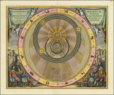
A 17th century illustration of Tycho Brahe's geo-heliocentric model of the universe. The image is from Andreas Cellarius' Harmonia Macrocosmica atlas and shows the Earth in the center around which the Moon and Sun revolve. At the same time, the planets Me
🖼 0.94 art
A 17th century illustration of Tycho Brahe's geo-heliocentric model of the universe. The image is from Andreas Cellarius' Harmonia Macrocosmica atlas and shows the Earth in the center around which the Moon and Sun revolve. At the same time, the planets Me
Kosmologisches Universum-Diagramm

imageBROKER/Sunny Celeste 13 184 × 10 946 px TIF

Historisches kosmologisches Diagramm aus dem 16. Jahrhundert zeigt das geozentrische Weltbild mit konzentrischen Planetenbahnen um die Erde. Prächtige…
Details
The magnitude of various celestial bodies and stars, 1660, digital improved reproduction of a work of Andreas Cellarius (1596-1665), a Dutch-German cartographer and cosmographer best known for his Harmonia Macrocosmica from 1660, a major star atlas, The m
🖼 0.93 art
The magnitude of various celestial bodies and stars, 1660, digital improved reproduction of a work of Andreas Cellarius (1596-1665), a Dutch-German cartographer and cosmographer best known for his Harmonia Macrocosmica from 1660, a major star atlas, The m
Ptolemäisches Weltmodell

imageBROKER/Sunny Celeste 13 090 × 10 972 px TIF

Die Größenordnung verschiedener Himmelskörper und Sterne, 1660, Kupferstich von Andreas Cellarius aus dem Sternenatlas Harmonia Macrocosmica. Hochauflösende…
Details
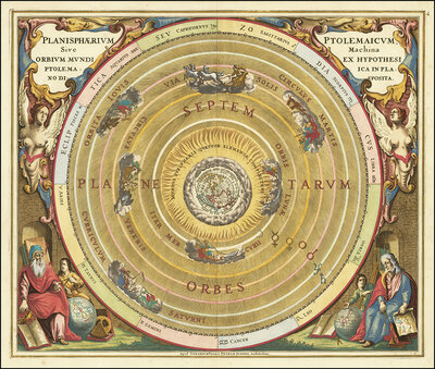
Presentation of the geocentric world view based on Claudius Ptolemy, as illustrated by Andreas Cellarius in 1660. This model assumes that the Earth is at the center of the universe and that all celestial bodies orbit it. The illustration shows the Earth i
🖼 0.92 abstract
Presentation of the geocentric world view based on Claudius Ptolemy, as illustrated by Andreas Cellarius in 1660. This model assumes that the Earth is at the center of the universe and that all celestial bodies orbit it. The illustration shows the Earth i
Ptolemäisches Planetariumsmodell

imageBROKER/Sunny Celeste 12 970 × 10 993 px TIF

Prächtiges historisches Planetarium nach Ptolemäus mit konzentrischem Orbitalmodell. Zentrale Erdkugel von golden leuchtenden Sphären umgeben, flankiert von…
Details
Historical celestial map depicting the Ptolemaic, geocentric, world view. The illustration comes from the atlas Harmonia Macrocosmica by the German-Dutch cartographer Andreas Cellarius and was originally published around 1660 or 1661. The planets Luna, Me
🖼 0.92 art
Historical celestial map depicting the Ptolemaic, geocentric, world view. The illustration comes from the atlas Harmonia Macrocosmica by the German-Dutch cartographer Andreas Cellarius and was originally published around 1660 or 1661. The planets Luna, Me
Ptolemäische Himmelskarte

imageBROKER/Sunny Celeste 12 970 × 10 993 px TIF

Historische Ptolemäische Himmelskarte mit konzentrischem Planetensystem. Aufwendig verzierte Kartusche mit Putten und Gelehrten in Renaissance-Stil. Warme…
Details
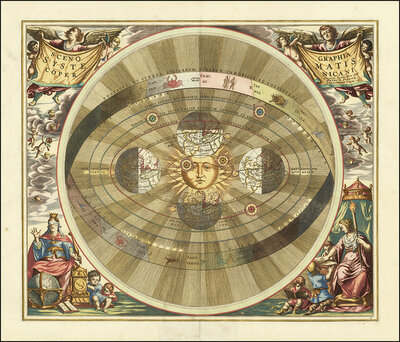
Scenographia Systematis Copernicani, scenography of the Copernican system, a celestial map illustrating the heliocentric world view, from the atlas Harmonia Macrocosmica seu Atlas universalis et novus published in 1660 by Andreas Cellarius, a German-Dutch
🖼 0.92 art
Scenographia Systematis Copernicani, scenography of the Copernican system, a celestial map illustrating the heliocentric world view, from the atlas Harmonia Macrocosmica seu Atlas universalis et novus published in 1660 by Andreas Cellarius, a German-Dutch
Kosmologisches Modell, Sonnensystem

imageBROKER/Sunny Celeste 13 430 × 11 486 px TIF

Historische kosmologische Darstellung mit geozentrischer Weltansicht. Zentrale Sonnenfigur umgeben von konzentrischen Planetenbahnen, reichhaltig dekoriert mit…
Details
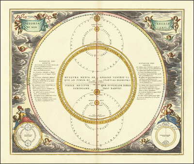
Historical illustration of the orbits of Mercury and Venus, which demonstrates the geoheliocentric world view according to Tycho Brahe. Theoria et Mercurii Veneris Cursus, theory and career of Mercury and Venus and depicts Mercury and Venus orbiting the S
🖼 0.92 art
Historical illustration of the orbits of Mercury and Venus, which demonstrates the geoheliocentric world view according to Tycho Brahe. Theoria et Mercurii Veneris Cursus, theory and career of Mercury and Venus and depicts Mercury and Venus orbiting the S
Astronomische Diagramm-Illustration

imageBROKER/Sunny Celeste 13 570 × 11 482 px TIF

Historische astronomische Darstellung mit konzentriscchen Kreisen und lateinischen Beschriftungen. Barocke Engel und allegorische Figuren umrahmen die…
Details
Historical map titled Scenographia Systematis Copernicani, scenography of the Copernican system. It comes from the Harmonia Macrocosmica sky atlas by Andreas Cellarius, which was published in 1660/1661 and represents Nicolaus Copernicus's heliocentric wor
🖼 0.92 art
Historical map titled Scenographia Systematis Copernicani, scenography of the Copernican system. It comes from the Harmonia Macrocosmica sky atlas by Andreas Cellarius, which was published in 1660/1661 and represents Nicolaus Copernicus's heliocentric wor
Geozentrisches Weltmodell

imageBROKER/Sunny Celeste 12 899 × 11 082 px TIF

Historische kolorierte Kupferstichdarstellung des geozentrischen Weltbildes mit der Sonne im Zentrum, umgeben von konzentrischen Kreisbahnen. Allegorische…
Details
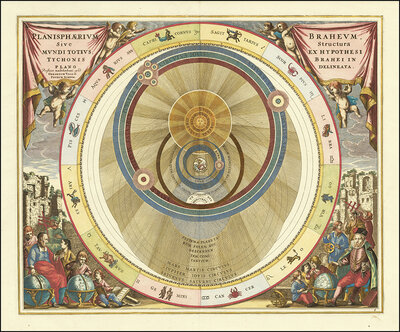
Planisphaerium Braheum, a famous historical celestial map illustrating the geo-heliocentric world model of the Danish astronomer Tycho Brahe. The engraving is by Andreas Cellarius and was published in 1660 or 1661 in the Atlas Harmonia Macrocosmica. At th
🖼 0.92 abstract
Planisphaerium Braheum, a famous historical celestial map illustrating the geo-heliocentric world model of the Danish astronomer Tycho Brahe. The engraving is by Andreas Cellarius and was published in 1660 or 1661 in the Atlas Harmonia Macrocosmica. At th
Kosmologische Himmelskarte

imageBROKER/Sunny Celeste 13 512 × 11 273 px TIF

Historische kosmologische Himmelskarte nach Brahe-Hypothese. Konzentrische Planetenbahnen um Erde mit aufwendiger Radialzeichnung. Renaissance-Kolorit mit Gold,…
Details
Scenographia Systematis Copernicani, scenography of the Copernican system. It comes from the celestial atlas Harmonia Macrocosmica by Andreas Cellarius, which was first published in 1660. The map illustrates the heliocentric view of the world as described
🖼 0.92 art
Scenographia Systematis Copernicani, scenography of the Copernican system. It comes from the celestial atlas Harmonia Macrocosmica by Andreas Cellarius, which was first published in 1660. The map illustrates the heliocentric view of the world as described
Kosmologisches Weltmodell

imageBROKER/Sunny Celeste 13 073 × 11 232 px TIF

Historische kosmologische Darstellung mit geozentrischen Planetenbahnen um die Sonne, umrahmt von Engeln und allegorischen Figuren. Warme Goldtöne, detaillierte…
Details
Historical presentation of the Tychonic world system, Tychonis Calculus, which was made by Andreas Cellarius for his famous atlas Harmonia Macrocosmica after 1600. The Tychonic System is a geo-heliocentric model in which the Earth is at the center, the Su
🖼 0.92 abstract
Historical presentation of the Tychonic world system, Tychonis Calculus, which was made by Andreas Cellarius for his famous atlas Harmonia Macrocosmica after 1600. The Tychonic System is a geo-heliocentric model in which the Earth is at the center, the Su
Himmelskarte, Planetenbahnen

imageBROKER/Sunny Celeste 12 783 × 10 400 px TIF

Historische Himmelskarte mit geozentrischen Planetenbahnen, konzentrische Kreise zeigen Umlaufbahnen um die Erde. Aufwendig ornamentierte Kartusche mit…
Details
Planisphaerium Arateum, part of the famous celestial atlas Harmonia Macrocosmica by Andreas Cellarius. Description The map shows the geocentric world view based on the observations and writings of the ancient Greek poet and astronomer Aratos (ca. 315 - 24
🖼 0.92 art
Planisphaerium Arateum, part of the famous celestial atlas Harmonia Macrocosmica by Andreas Cellarius. Description The map shows the geocentric world view based on the observations and writings of the ancient Greek poet and astronomer Aratos (ca. 315 - 24
Geozentrisches Planetarium

imageBROKER/Sunny Celeste 13 339 × 11 285 px TIF

Historische kosmologische Darstellung des geozentrischen Weltbildes mit konzentrischem Orbitsystem, Planetenscheiben und mythologischen Figuren. Prächtige…
Details